Trinidad
People and the Northern Range, Trinidad
Project Summary
The Northern Range (Figure 1) is a complex ecosystem covering approximately
twenty-five percent of the land area of the island of Trinidad, one of the
two islands, located in the southeasten Caribbean, that comprise the twin
island republic of Trinidad and Tobago. For the purpose of this assessment,
the Northern Range is defined as the region bounded on the north by the
coastal strip, on the south by a main road artery (the Eastern Main Road),
and including the city of Port-of-Spain and the western offshore islands.
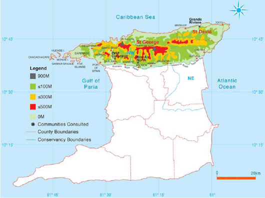
Figure 1. Northern Range topography and study areas.
The watershed areas of the Northern Range are the most significant contributors
to the freshwater supply for the island of Trinidad, and they also help
to control flooding in the low-lying regions at the foothills of the Range,
especially on the southern flanks. However, the Range also provides vital
space for housing and agriculture; is important for ecotourism and recreation;
provides opportunities for small-scale freshwater and coastal/marine fishing
for some Northern Range communities; affords safe harbours on the coastal
strip in the southwestern region; contributes to local climate regulation;
and also provides other economic activities through timber harvesting, wildlife
hunting and the manufacture of goods from non-timber forest products. One
notable feature of the Range is its relatively high biodiversity, which
represents a combination of species from the South American continent, and
from the Caribbean islands further north in the island archipelago.
There are multiple drivers of ecosystem change in the Northern Range.
Drivers of land use change include urbanisation, upgrade of housing, slash
and burn and other unsustainable agricultural and land clearing practices,
and increased demand for recreational activities. Increasing variability
in weather patterns drives change in runoff regulation services. Lack of
public policy and planning and ineffective monitoring of environmental impact
of policy is also detrimental to the ecological integrity of the Northern
Range.
Because of its geology, the Northern Range is particularly vulnerable
to erosion and degradation. Although most of the Range has experienced human-induced
ecosystem change, the most seriously degraded areas are the southern flanks
of the western section. The eastern section is hitherto less degraded, but
pressure is increasing. The steep northern slope has also experienced increases
in population and commensurate degradation as a result of inappropriate
land-use, in particular the building of luxury vacation homes. Unregulated
mining, agriculture, and forestry have all contributed to the declining
state of the range. Projections indicate that further conversion, degradation
and decline in ecosystem services will continue throughout the Northern
Range unless appropriate policy measures are implemented to check the driving
forces of ecosystem change in the Northern Range.
Assessment Approach
This assessment relied on published scientific literature, supplemented
by professional input and community perspectives. The assessment was organised
on the basis of three components, each a subsystem of the Northern Range:
forests, freshwater, and coastal resources. Biodiversity and land use were
evaluated as cross-cutting themes in all of the subsystems. Additionally,
the amenity value of the subsystems were considered throughout the assessment
and at multiple scales. Responses to the driving forces identified by the
assessment were evaluated, and further response options presented.
The assessment was prepared as an aid to contribute to the process of
public policy formulation and appropriate management for sustaining the
Northern Range and its ecosystem services.
Lead Institutions
This assessment was conducted through cooperation by the following organisations:
The Cropper Foundation, The University of the West Indies (Trinidad campus),
The Environment Management Authority of Trinidad and Tobago, The Tropical
Re-Leaf Foundation, and The Trust for Sustainable Livelihoods. Approximately
thirty individuals contributed to the assessment work.
Funding for this assessment was provided by: MA, The Cropper Foundation,
and the British High Commission to Trinidad & Tobago.
Contact information
Focal Issues
The primary focal issue of this assessment was people’s needs and nature’s
capacities to provide for those needs. As such, the following issues were
explored:
- Development pressures and environmental realities;
- Scientific reasoning and community knowledge;
- Natural science and social science understanding;
- Public interest and private interests;
- Present situation and future prospects; and
- The many activities, actors and ideas.
Ecosystems services assessed
Freshwater, timber and non-timber forest resources, climate regulation,
air, soil and nutrient cycling, tourism and recreation, coastal features
(including wetlands, beaches, harbours, seagrasses, algal communities and
coral reefs), and artisanal fishing. The amenity value of land and marine
resources and biodiversity were also included in assessment as cross-cutting
themes relevant to all services and scales of the ecosystem.
Project Outputs and Results
Although there is very little reliable data on the extent of forest cover
in the Northern Range, it is clear that forests have declined in extent
and quality of cover, especially in the western section. The eastern section
is now under threat from encroachment through housing and agriculture. Loss
of forest cover has exacerbated soil erosion and flooding, which has resulted
in damage both at the source and further downstream. Other threats to the
ecological integrity of the forests are forest fires in primary forests,
increased unsustainable land use for recreational and education purposes,
and poor zoning and policy.
On the island as a whole, freshwater resources are threatened as a result
of deforestation and pollution. Faulty water distribution infrastructure
is responsible for losses of between 50-60% of water supply before it reaches
consumers. p>
Coastal resources are under threat from land-based and coastal activities,
including intensive use for recreational purposes. Major causes of disturbance
are coastal development, land-based activities which contribute to pollution
and eutrophication, over-exploitation of coastal resources and natural disasters.
The protected Chaguaramas Bay, which provide safe anchorage for boats and
yachts, is under intensive use, which is an economic boon to the area, but
also contributes to pollution of the coastal waters.
Current data on the state of fisheries and catch in Trinidad and Tobago
is limited. However, indicators suggest that catch has declined in both
fresh and saltwater bodies.p>
Amenity value of the range has declined as a result of environmental
degradation. Demand for these services, however, has increased. Maintaining
amenity value to satisfy user demands would sustain capacity for the regulating
and supporting services.. This positive relationship is relevant and should
be considered in formulation of policy decisions regarding both long and
short-term management and use of natural resources.
The assessment identified lack of political will, coordination, and
policy for sustainable resource use as primary hindrances to improving the
condition of the Northern Range. Therefore, the assessment recommended review
and implementation of existing policies and development of new policies
for sustainable management. A comprehensive new plan for the Northern Range
would benefit from inclusion of the following elements:
- Zoning of the eastern section of the northern Range for conservation
purposes;
- Revised contour and slope limits for housing construction in the
western section;
- Urgent executive and legislative action proposals on Environmentally
Sensitive Areas and Species;
- Local area physical development plans (required by the Town and
Country Planning Act 1968) compatible with the overall plan for the
Northern Range;
- Multi-lateral, multi-agency decision-making processes; and
- Increased collaboration amongst all stakeholders.
In addition to government involvement, civil society should be educated
in regard to its rights and responsibilities regarding natural resources.
More attention should be put to where and how funds are used, and user fees
and fines for non-compliance should be considered for income generation
for specific amenity sites. Monitoring, evaluation and academic research
should also be encouraged in the region.
Reports
Links