Peru
Vilcanota Sub-region
Contact Information
Lead Institutions and User Groups
The assessment will be undertaken by the International Center of Traditional
Knowledge, Ecology, and Policies (CICTEP), which is a project of the Asociación
ANDES, a community-based Quechua-Aymara organization working on conservation
and livelihoods promotion in the Andes region. To undertake the assessment,
CICTEP will work closely with the Ausangate Community Association (a community
organization of Ausangate sub-region associated to ANDES) made up of the
indigenous communities of Tinqui, Tayancany, Cotaña, Mahuayani, Pausipanpa,
and Anjasi.
The primary users of the assessment will be the communities of Tinqui,
Tayancany, Cotaña, Mahuayani, Pausipanpa, Anjasi which form the Ausangate
assessment area. Surrounding communities and the municipality of Ocongate
will also use the assessment. The assessment will be completely user-driven.
Focal Issues
The main objective of this assessment is to assess the state of the ecosystem
in the Vilcanota sub-region of the Peruvian Andes (Figure 1). It is imperative
to do so as soon as possible due to the increasing intensity of global dynamics
and drivers of ecosystem change, such as mass tourism and mining. These
impacts are significant at the sub-regional and local level, particularly
in terms of the ecological and socio-cultural dimensions. This may cause
short and long-term loss of capacity for self-reliance, and the erosion
of biological and cultural diversity.
Ecosystem Services
Cultural services (spirituality); provisioning services (water, food);
supporting services (soil, primary production). Agrobiodiversity will also
be assessed.
Key Features of the Assessment
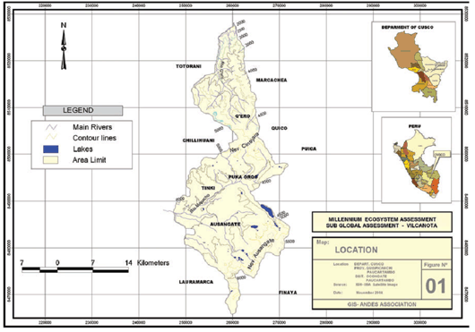
Figure 1. Vilcanota, Peru assessment area.
The Vilcanota sub-region is the second most important ice-capped mountain
range of the Peruvian Andes. It comprises 469 glaciers in an area of 539
square kilometers. The mountain range is the origin of an extended watershed
system. The Ayacachi and Central Vilcanota systems are located in the northeast.
In the north, the main systems are Qosnipata and Pilcopata, which border
the Manu National Park. To the east the Marcapata and San Gaban are the
main watersheds, and in the south is located the Vilcanota system, which
constitutes the Sacred Valley of the Incas. These systems border two main
differentiated ecosystems at the regional level: the Amazon rainforest to
the east and the Andean valleys to the west.
This ecosystem differentiation, as well as historical factors, have produced
a very rich biological and cultural diversity in the region characterized
by the existence of a large number of endemic species. Rich local knowledge
and practices have made possible the adaptive management of natural resources
for sustaining local livelihoods. Locals believe that systems and values,
including the treatment of mountains as divinities, have allowed for the
maintenance of a strong local cultural identity that approaches nature on
the basis of concepts of relatedness to the natural world.
The area is also a known hot spot of biodiversity in the region, characterized
by the existence of a large number of endemic species. It also an area of
concentrated native agrobiodiversity and livestock populations. Natural
resources are now under pressure and local land users have little means
to improve their livelihoods. Present day changes and the influence of a
liberalized world economy, particularly mining and tourism, have created
social and cultural tensions and ecological degradation, making it particularly
crucial to carry out an ecosystem assessment in this important ecoregion.