Australia
Northern Australian Floodplains
Contact Information
- Peter Bayliss
Environmental Research Institute of the Supervising Scientist
GPO Box 461
Darwin, Australia
peter.bayliss@cgiar.org
- Max Finlayson
International Water Management Institute
PO Box 2075
Colombo, Sri Lanka
m.finlayson@cgiar.org
Lead Institution
Environmental Research Institute of the Supervising Scientist (ERISS). The Institute is a part of the Australian Federal Department of Environment and Heritage.
Project Objectives
To provide information on the floodplain and coastal ecosystems and their services of the tropical floodplains to the east of Darwin, Australia (Figure 1) (including the Mary and Alligator rivers, which encompass the World Heritage and Ramsar Convention listed Kakadu National Park, and the Blythe-Liverpool rivers in Arnhem Land), noting information needs and analyses at multiple scales and taking into account multiple pressures on these ecosystems.
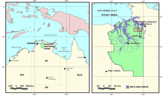
Figure 1. Study area for Northern Australia Floodplains assessment.
Methods
Project components
- Inventory/mapping- GIS multiple scale;
- Floodplain services- indigenous use, biodiversity, tourism, recreation, fish stocks, mitigation of climate change, cattle grazing;
- Risk assessment of major pressures - invasive species, water pollution, infrastructure, burning, climate change.
The project was linked with other assessment and management activities being undertaken in the same location by indigenous people and park managers with their own planning/reporting procedures.
Scales
The landscape analyses comprised sub-projects that addressed mapping at scales from:
- Biogeographical or catchment scale: 1:100 000 to 1: 250 000
- Catchment scales 1:500 000 to 1:100 000
- Habitats/ river reaches 1:10 000
Risk assessment framework (modified from van Dam et al. 1999 and Ramsar 2000):
- Identification of the problem;
- Analysis
- Identification of the risk;
- Risk management/risk reduction;
- Monitoring.
A hierarchical approach to wetland inventory was used for the assessment and is presented in Figure 2.
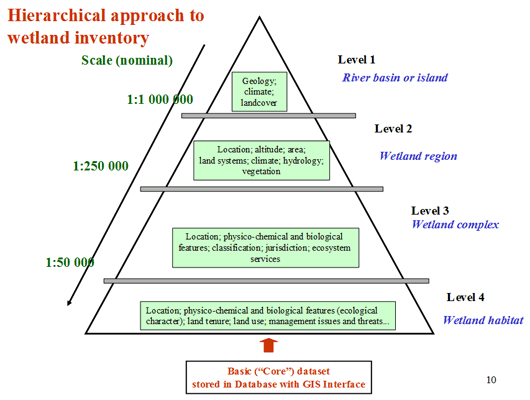
Figure 2: Hierarchical approach to wetland inventory.
Products
The primary purpose of the landscape-scale analyses is to provide information for managing the aquatic ecosystems within the region, noting that the responsibility for management decisions is shared between local landholders, governmental agencies, and resource managers. As the Institute does not directly manage ecosystems or their services it is necessary to present research/assessment outcomes in formats suitable for ready access by all stakeholders and decision-makers. The Institute already operates a transparent system for access to data and reports and specifically provides information to major stakeholders through formal and informal reporting procedures. This includes but is not limited to the Alligators Rivers Region Technical Committee. As a publicly-funded institution, all information collected by the Institute is made available. An annual report is presented and where possible information is published in the scientific literature. Copyright is retained in the public domain with publication in specific formats covered by non-exclusive permits.
Next Steps
On-going steps in the project include further consultation with participants, advisors and stakeholders; collation and analysis of data based on both current and previous projects; and communication in discussing and finalising analyses and outcomes.
Publications
- Finlayson, C.M. 2005. Plant Ecology of Australia’s Tropical Floodplain Wetlands: A Review. Annals of Botany 96: 541–555, 2005. Download
- Finlayson, C. Max, John Lowry, Maria Grazia Bellio, Suthidha Nou1, Robert Pidgeon, Dave Walden, Chris Humphrey and Gary Fox. 2006. Biodiversity of the wetlands of the Kakadu Region, northern Australia. Aquat. Sci . 68 (2006) 374–399. Download
- Finlayson, C. Max and Rick A. van Dam. 2003. Developing Local Capacity and Ensuring Relevance in Risk Assessment for Tropical Wetlands. Environmental Research Institute of the Supervising Scientist ( eriss ), Darwin, NT, Australia. SETAC Globe 2004. pages 36-38 Download
- Finlayson, C. Max, Maria Grazia Bellio and John Lowry. 2005. A Conceptual Basis for the Wise Use of Wetlands in Northern Australia-Linking Information Needs, Integrated Analyses, Drivers of Change and Human Wellbeing. Marine and Freshwater Research 56: 269-277. CSIRO Publishing. Download
- Supervising Scientist 2006. Ecological risk assessment of Magela floodplain from diffuse landscape-scale threats and point source mining threats. in Annual Report 2005-06, Supervising Scientist , Darwin. Pp. 61-74. Download
- Finlayson, Max. Northern Australia Floodplains and Coastal Wetlands. Powerpoint presentation. Download