Eastern Himalayas
Contact Information
- Ankila Hiremath ATREE
659, 5th A Main Road
Hebbal Bangalore 560024
India
hiremath@atree.org
- Lead Institution: Ashoka Trust for Research in Ecology and the
Environment (ATREE)
Location
The Darjeeling district, covering an area of 3,149 square kilometers
Indirect Drivers of Change
- Population growth: Population explosion over
the years has been one of the main problems in the Darjeeling hills,
resulting from a number of factors. Uncontrolled family expansion,
immigration from other regions of India, and migration from nearby
countries due to the establishment of tea plantations have all
contributed to increases in population in Darjeeling. Additionally,
the popularity of the region for tourists has contributed to
population growth.
- Family fragmentation: The village communities
have started moving toward nuclear-type families, resulting in land
that is more fragmented and less suitable for the practice of
subsistence agriculture. In 1956, for example, Karmat village had 24
houses; in 2003, as a result of families splitting up, the number of
houses in the village had increased to 65, with an average size of 6
family members.
- Economic status: Economic self-sufficiency and
alternative livelihood options are severely lacking in the hills due
to the lack of resources and the absence of alternative job
opportunities. Villagers located in the mountainous terrain at an
altitude of between 1,800 and 3,600 meters have to purchase basic
necessities including staple foods such as rice and dal (pulses)
from the nearest urban centres. Price fluctuations of these staples,
along with transportation costs, encourage villagers to sell
fuelwood for income generation.
- Policies, institutions, and processes: Despite
implementation of a wide range of policies, institutions, and
processes, the government’s capacity building measures have not
achieved diversification of livelihood patterns in the villages.
Often the secretary of these committees is nominated by the
government, and the villagers are not made aware of the activities
underway and the budget allocated.
- Change in local land use patterns: Family
fragmentation has resulted in fragmentation of agricultural land and
clearing of forest land for settlement. This land use pattern has
also played a major role in the degradation of ecosystems and in
causing landslides and flooding. The recent proposed sites of Teesta
Dam Stage IV and Ramam Hydel Project and Nuclear Laboratory will
result in the submergence of villages and the fragmentation of flora
and fauna. The Kalikhola mini hydel project will lead to the loss of
faunal habitat, which can accentuate the conflict between humans and
animals in the villages and lead to loss in agricultural production.
Ecosystem Services
- Non-wood forest products (fruits, vegetables, and
medicinal plants): The village communities in the protected
areas are extracting NWFPs at a subsistence level. Woody and fibrous
construction materials are required for agriculture implements,
cattle sheds, and repair of houses. Studies have shown that there
has been an over-extraction and exploitation of medicinal plants
such as Aconitum bisma, Aconitum spicatum, Dactylorhiza hatagirea,
Heracluem wallichii, Neopicrorhiza scrophulariiflora, Panax
pseudoginseng subsp himalacus, Podophyllum sikkimense, etc.
- Water: Water-related problems affect the
village communities of the three protected areas of the assessment.
The village communities are aware that the driving force of the
problem is felling of trees and clearing of forest in the
catchments. Two lakes built inside the Sepahijala Wildlife Sanctuary
at the turn of the twentieth century demarcated 447.4 hectares as
catchment areas for drinking water supply to Darjeeling town. The
catchments were securely protected by barbed wire fencing. Today,
the fence is as good as nonexistent. At least 81% of the catchments
are denuded. When protection was provided to the catchments, nearly
26 streams regularly supplied water to the lake. Today, only 14 of
those streams are still flowing. This situation has resulted in an
acute water crisis in Darjeeling.
- Soil: Soil fertility has been affected by the
use of chemicals like urea and diammonium phosphate. Additionally,
faulty agricultural practices such as tilling of land during monsoon
season have resulted in erosion of topsoil. The villages located in
the hilly region have not adopted contour bunding in their terraces.
Cultivation methods for growing vegetables have resulted in
landslides and soil erosion.
Responses
The northern region of West Bengal has a long-standing tradition of
symbiotic relationships between the local communities and the forests.
From independence, however, the government’s approach to the local
people became mainly confrontational, leading to severe negative impacts
in terms of conflicts between the local communities and the forest
departments. Conflict has also led to the proliferation of the illegal
trade in timber and other ecosystem products. The importance of
involving the local people in protected area management was realized in
the early 1970s when UNESCO’s Man and Biosphere Reserve Program began to
promote the creation of buffer zones between the strictly preserved
areas and human settlements. India’s Department of Environment created a
Board of Ecodevelopment in 1982–83, after the World Congress on National
Parks in Bali gave impetus to the objective of linking protected area
management with economic activities of the local people by advocating
the implementation of joint management between the societies which
traditionally managed these forests and the protected area authorities.
Following this, the Joint Forest Management (JFM) Program was initiated
through the National Forest Policy of 1988. This concept extended the
“ecodevelopment” program to the protected areas, which not only reduces
the impact of the people on the protected area but also fosters better
communication between the local communities and the protected area
management authorities.
Scenarios
The ecosystem in the Darjeeling Himalayas has been under tremendous
human pressure over the years. Even though some remedial measures have
been initiated involving the communities and the government agencies,
success has been only partial. The consequences of the continuing
exploitation of the ecosystem services, if unchecked, will have a major
impact on the state of the environment. The assessment developed four
plausible scenarios for the region, calling them “No Action,” “Varied
Experiments,” “Technological Fix,” and “Development Fix.”
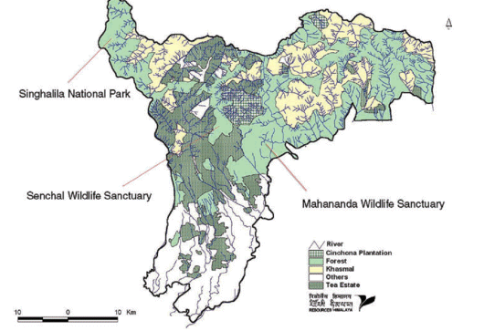
Figure 1 Eastern Himalayas SGA region.